S4 Hike #8 Smith Rock
Smith Rock State Park
Starting Location: parking lot - Welcome Center
Point of Interest : Smith Rock, rock formations, Crooked River
Length of hike:
- Many Hikes Available (Trail Map)
- Misery Ridge Loop 4 miles
Level: Misery Ridge trail is hard, to to steepness, some loose gravel. River trail is easy.
Bathrooms: at main parking lot, and down by river.
Parking: Decent paved lot along the road.
EV Chargers: No
Obviously there were groups who had come early and were finished hiking. There were a lot of people, but it didn't feel too crowded. There are trails for everyone.
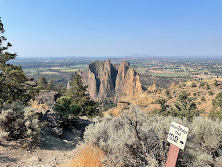
Our first time at Smith Rock. We decided to do the Misery Ridge loop, which includes the Mesa Verda trail which joins with the river trail to bring you back to the beginning.
The Misery Ridge trail is aptly named, mostly due to steepness. It's only a mile long, but it took us a little over an hour to get to the high point. The view, however, is worth it.
Then we came down the "back side" of the rock, facing West. Most people were doing the hard part first, but the loop is a loop, so you can go either way.


This blog is very informative for travelers. The pictures are gorgeous and lovely 😊
ReplyDelete